New Urban Order
In the late colonial period, Mexican cities expanded as Atlantic trade and a boom in mining production brought new wealth and population. Urban society grew more complex, and increased mixing of races and greater class mobility altered traditional patterns of sociability and urban life. In the eighteenth century, royal reformers influenced by Enlightenment political, economic, and cultural ideals imposed a new urban order in Mexico and throughout the Spanish empire. They restructured city spaces, policed streets, and regulated public diversions in an attempt to shape not only the administration but also the morals of cities and their inhabitants.
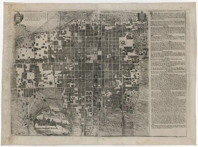
Named a master architect of Mexico City in 1763, Ildefonso de Iniesta Bejarano designed several iconic civil and religious buildings in the city. He was one of the foremost proponents of the ornate baroque style called churrigueresque, readily visible in his building projects such as the Oratory of San Felipe Neri, the new façade of the Royal and Pontifical University, and the Santa Veracruz and La Santísima churches. Iniesta created this map of Mexico City not long before the viceregal government in 1782 divided the city into cuarteles (quarters) under the watch of a system of alcaldes de barrio (neighborhood officials). Predating the cuarteles system, Iniesta’s map and the chart he includes at top right reflect the traditional role of religious institutions such as parishes and convents in defining urban spaces throughout the colonial period.
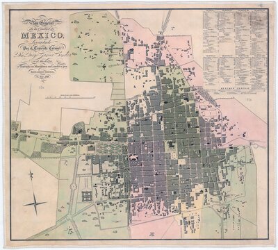
This Mexico City map was surveyed and drawn by Diego García Conde, a Spanish soldier and engineer, in 1793. Its first printing in 1807 by José Joaquín Fabregat, the director of engraving at the city’s royal academy of the arts, was on a monumental scale, measuring 63 x 80 inches.
The plates from the 1807 printing were lost, but this smaller edition was printed in London in 1811. The map demonstrates the Bourbon viceregal government’s desire to order the city and control public spaces and diversions. In contrast to the map that the royal architect Iniesta Bejarano produced in 1778, in which religious institutions anchored the city view, García Conde’s map divides and color-codes Mexico City according to the system of administrative cuarteles (quarters) established in 1782. The map identifies every street, plaza, and pulquería, serving the government’s efforts to regulate social life and vice—particularly among the city’s mestizo and indigenous lower classes—in the name of enlightened reform.
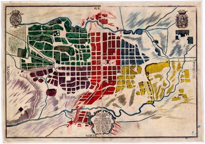
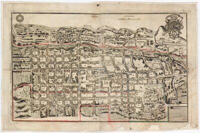
These two maps of Valladolid (now Morelia) and Queretaro reflect the extension of the cuarteles system beyond Mexico City to other colonial cities during the 1790s, by order of the viceroy. Cuarteles were also instituted in Oaxaca, Puebla, San Luis Potosí, and Zacatecas around this time, dividing the cities into zones for administrative and policing purposes.