Territory and Nation
After the wars of conquest in the sixteenth century, military conflict gave way to a colonial enterprise centered on political, social, and economic development that took root in central Mexican communities and cities and slowly extended outward. But as colonial rule gave way to the wars of independence and early statehood in the nineteenth century, territorial defense and military matters once again became central concerns. A rapidly changing Mexico confronted new political instability and competing claims to territory, particularly along its sparsely settled northern borders.
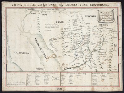
Mission territories were integral to Spanish settlement and control of the Northern Mexican frontier in the eighteenth century. To preserve communication between their far-flung missions and central authorities, Jesuit administrators such as Juan Antonio de Balthasar made official visitas to assigned territories to report on mission activities.
This map of the Sonora missions was created in the wake of the Pima Revolt of 1751, one of several major indigenous uprisings that contributed to growing military crisis in the borderland. The political instability also weakened the Jesuits’ position on the northern frontier and their relationship with the crown. Balthasar, then the Jesuit Superior in New Spain, likely intended for the map to reflect the order and stability of the Sonora mission territories. But the map also represents the strength of indigenous resistance to the Spanish, with surrounding territories identified with Yuma, Opa, Seri, Apache, and Hocome peoples notably unmarked by Spanish settlement.
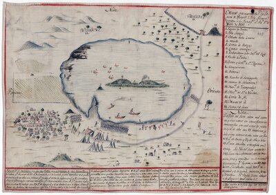
The provenance of this map is unknown, but the paper and writing style suggest that it was made soon after the War of Independence battle it portrays—the defeat and capture of an insurgent stronghold at Yuriria, Guanajuato, on November 1, 1812.
In the summer of 1812, the insurgents made Yuriria their northern headquarters, with José María Liceaga in command. They fortified two islands in the middle of Lake Yuriria, building up a military bunker, munitions factory, and printing operation. Rumored to be impenetrable, Isla Liceaga was no match for Colonel Agustín de Iturbide, who led royalist troops in a violent siege both from the mainland and via canoes and rafts. The battle was significant for both sides, promoting the career of Iturbide, who would seize power in independent Mexico in 1821, and strengthening the resolve of Liceaga and insurgent forces in the independence struggle.
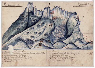
Like the 1812 map of the battle at Lake Yuriria, this hand-painted map depicts another stronghold of the insurgent forces during the Mexican War of Independence. But this document represents a victory for the revolutionaries, highlighting General Vicente Guerrero’s defeat of a September 1818 royalist attack on the Cerro de Barrabás, a hilltop fortification. This map’s dramatic visual representation of the tall, rocky fortress underscores the guerrilla nature of the insurgent struggle in its later phases and the central role of the Mexican landscape in the military conflict.
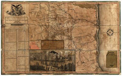
Before mass printing of maps was common, military draftsmen routinely copied field maps by hand. General Mariano Arista, commander of the Mexican Army of the North, ordered Colonel José Juan Sánchez to produce this copy of the general’s own map of northeastern Mexico for his second-in-command, General Isidro Reyes. Sánchez was an accomplished draftsman, and the note found at the right of this map, along with other evidence, suggests that he was the creator of the larger original for Arista as well as this smaller area detail for Reyes.
Sánchez’s map was a categorical improvement over existing maps of northeastern Mexico. It offered unprecedented detail and extreme accuracy in its identification of every settlement, path, landmark, and water source in its boundaries, reflecting the draftsman’s deep knowledge of the territory. In addition to topographical features, the map records sites of conflict with both Comanches and Tamaulipas federalist rebels. It also affirms Mexico’s historic claim to its northeastern border at the Nueces River, a claim in dispute with independent Texas at the time.
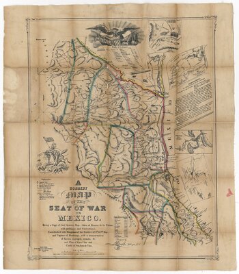
The battle at Resaca de la Palma, near present-day Brownsville, TX, on May 8-9, 1847, was one of the first conflicts of the U.S. – Mexico War. General Zachary Taylor and U.S. troops delivered a humiliating defeat to Mexican General Mariano Arista, overtaking his encampment and seizing his personal belongings, including his papers and maps. One map in particular, a hand-drawn field map created by Arista’s inspector José Juan Sánchez and possibly others, offered the U.S. army detailed topographical and travel information that far surpassed any knowledge they possessed—an intelligence coup that likely changed the course of the war.
A copy of the Mexican map quickly found its way to the East Coast, where mapmaker J.G. Bruff designed a version that printer John Disturnell published and sold. This version of Arista’s map, along with Disturnell’s 1847 map of the United States of Mexico, known as the “treaty map” for its use in negotiating the peace in 1848, became two of the most important maps of the U.S. – Mexico war. Their quick production and success reflect public interest in the details of the war and mark the emergence of printed maps as a new mass medium.